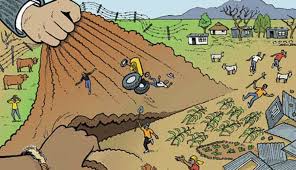
Land claims, whether legitimate, fraudulent or opportunistic, can cripple farms, businesses and their families. Thousands of land transactions, financing applications and plans to develop or expand have been scuttled by land claims, and this has cost South Africa incalculably in terms of jobs and rural development.
Continue reading…
SAAI Discloses Land Claims Database Online! Files Contempt of Court Against Agriculture Minister Thoko Didiza
Posted on Leave a comment
Globalist Campaign of Farmers Being “The Enemy of The State”, Strikes The Netherlands & Belgium
Posted on Leave a comment
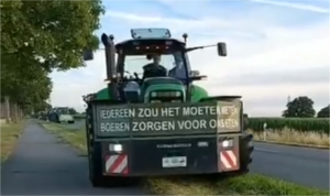
The Netherlands is still inherently an agricultural country, which produces a colossal result by surface area, placing it second in the world ranking for agricultural and horticultural product exports. The Dutch farmers and horticulturists form the historical platform of a prosperous Netherlands. However, the globalist Rutte/Kaag government, following World Economic Forum policy, has implemented the plan to liquidate/buy out a significant part of these farmers and agricultural companies.
Continue reading…
Young South African Girl Jailed for Life in Thailand after Signing for Parcel Containing Drugs, Addressed to her Employer!
Posted on Leave a comment
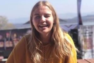
Family, friends and an ever increasing group of concerned supporters, of Ashley Oosthuizen (22), an innocent South African who was imprisoned for life in a Thai jail two years ago, are appealing to the ANC government in SA to pay urgent attention to her case. Oosthuizen’s family also fear that they will now rarely be able to contact her, after she was recently moved to a new prison. Her parents have apparently last spoken with her in December last year.
Continue reading…