The Far Left has already being ridiculed for calculating global cow farts, so it certainly is not beyond them to count how much CO₂ humans exhale! As if it wasn’t bad enough that we were forced to stay in our own homes, even though no one would have believed it before 2020, it now appears that it is not long before our own breath will be measured and counted! A Dutch bankster and professor, Barbara Baarsma from Rabobank, wants to give citizens personal annual CO₂ quotas! If the far left is already counting the emissions from cows, how long before they start measuring the CO₂ we emit with every breath?
Continue reading…
Are Globalists Planning to Charge us to Breathe? What is your breath worth?
Posted on Leave a comment
Petition: Make Peace NOT War! Invite both Ukraine & Russia to join NATO & EU to ensure lasting peace!
Posted on Leave a comment

The best way to ensure permanent and lasting peace on the European continent, is to let both Ukraine AND Russia join the very organisations that claim to maintain peace and stability in Europe.
Continue reading…
Young South African Girl Jailed for Life in Thailand after Signing for Parcel Containing Drugs, Addressed to her Employer!
Posted on Leave a comment
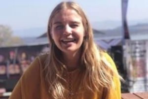
Family, friends and an ever increasing group of concerned supporters, of Ashley Oosthuizen (22), an innocent South African who was imprisoned for life in a Thai jail two years ago, are appealing to the ANC government in SA to pay urgent attention to her case. Oosthuizen’s family also fear that they will now rarely be able to contact her, after she was recently moved to a new prison. Her parents have apparently last spoken with her in December last year.
Continue reading…